Gaspee Virtual
Archives Virtual
Archives |
| 1777
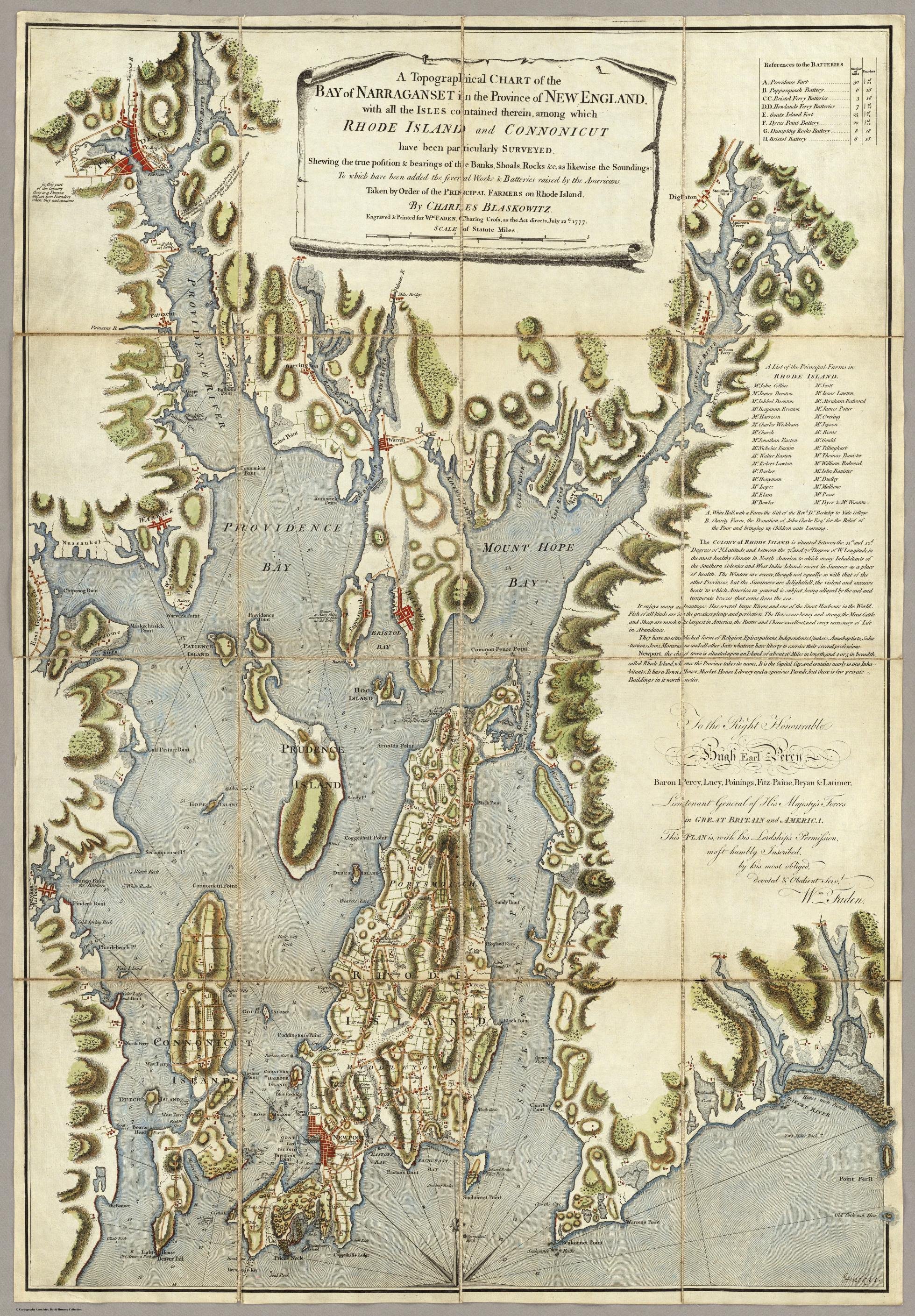
Map of Narragansett Bay by Charles Blaskowitz,
London.
1771 revised in 1777
Digital image courtesy of the David Rumsey Historical Map Collection, with permission. |
| Map text
reads
as follows:
A Topographical CHART
of
the |
References to the BATTERIES | Number of Guns | Pounders | |
| A List of the Principal
Farms in RHODE
ISLAND. Mr. John Collins Mr. Scott Mr. James Brenton Mr. Isaac Lawton Mr. Jahleel Brenton Mr. Abraham Redwood Mr. Benjamin Brenton Mr. James Potter Mr. Harrison Mr. Overing Mr. Charles Wickham Mr. Jepson Mr. Church Mr. Rome Mr. Jonathan Easton Mr. Gould Mr. Nicholas Easton Mr. Tillinghast Mr. Walter Easton Mr. Thomas Banister Mr. Robert Lawton Mr. William Redwood Mr. Barker Mr. John Banister Mr. Honyman Mr. Dudley Mr. Lopez Mr. Malbone Mr. Elam Mr. Pease Mr. Bowler Mr. Dyre & Mr. Wanton. A. White Hall, with a Farm, the Gift of Revd. Dr. Berkeley to Yale College B. Charity Farm,the Donation of John Clarke, Esqr, for the Relief of the Poor and bringing up Children unto Learning. |
| The COLONY
of
RHODE ISLAND is situated
between
the 41st. and 42d. Degrees of N.Latitude, and between the 71st. and 72d. Degrees of W.Longitude, in the most healthy Climate in North America, to which many Inhabitabts of the Southern Colonies and West India Islands resort in Summer as a place of health. The Winters are severe, though not equally so with that of the other Provinces, but the Summers are delightfull, the violent and excessive heats to which America in general is subject, being allayed by the cool and temperate breezes that come from the sea. It enjoys many advantages. Has several large Rivers, and one of the finest Harbours in the World. Fish of all kinds are in the greatest plenty and perfection. The horses are boney and strong, the Meat Cattle and Sheep are much the largest in America, the Butter and Cheese excellent, and every necessary of Life in Attendance. They have no established form of Religion. Episcopalians, Independents, Quakers, Annabaptists, Saba-tarians, Jews, Moravians, and all other Sects whatever, have liberty to excercise their several professions. Newport, the chief town is situated upon an Island, of about 16 miles in length, and 4 or 5 in breadth, called Rhode Island, whence the Province takes its name. It is the Capital City, and contains nearly 10,000 Inha-bitants. It has a Town House, Market House, Library and a spacious Parade, but there is few private Buildings in it worth notice. |
|
Hugh Earl Percy, Baron Percy, Lucy, Poinings, Fitz-Paine, Bryan & Latimer, Lieutenant General of His Majesty's Forces in GREAT BRITAIN and AMERICA. This PLAN is, with his Lordship's Permission, Most-humbly Inscribed by his most obliged devoted & Obedient servt, Wm. Faden. |
| Notes on
the Blaskowitz map: This striking chart shows both topographical and hydrographical detail throughout Narragansett Bay and was the result of a survey by Charles Blaskowitz, a skilled British military surveyor who was assigned by Samuel Holland in 1764 to chart the coast of Rhode Island and see if the harbor of Newport could be used as a British Naval Base. On the other hand, the bastard may have been paid by the Rhode Island farmers to create a map for their purposes in 1771, then redrew the map with the positions of the defensive batteries and resold it to the British in 1777. Recognized for its excellence in detail, the chart was subsequently used by the British after their occupation of Newport and deployment of their ships in the Bay, in the Revolutionary War. The chart shows Providence & Providence Bay, Mount Hope Bay, Conanicut Is., Prudence Is., Hog Is., Bristol Bay, and principal coastal towns. It also shows a street block plan of major towns. It also locates forts, batteries, principal farms with farmers names; harbors, capes, points, bays and islands, soundings, shoals and dangers in the Bay....but Gaspee (Gaspe) Point is not prominently listed as a danger (You'd think they would have learned). Of note for our purposes, is that Blaskowitz misspelt Pawtuxet as Patuxent, mislabelled Occupasspatuxet Cove as Patuxent Cove, and mislabelled Green Island as Little Island. |